OpenStreetMap - это карта всего мира,
которую может редактировать каждый,
которая создается практически с чистого листа
и распространяется под свободной лицензией.
Первоисточник: http://www.openstreetmap.org
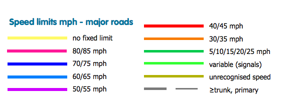
ITO Map overlay showing the value in maxspeed=* for highway=motorway, highway=trunk and highway=primary for area that show speeds as miles per hour. Yellow is used for ways with maxspeed set to 'none' (some states in the USA), dark blue for '70 mph' (and '70mph'), light blue for 60/65 mph, purple for 50/55 mph, red for 40/45 mph and orange for 30/35 mph. Where a maxspeed is set to another value is it shown as 'tan'. If maxspeed is not set then for the above road classes the road is shown in black. Note that speeds much end in 'mph' with an optional but preferred space between the number and the letter 'mph'.