OpenStreetMap - это карта всего мира,
которую может редактировать каждый,
которая создается практически с чистого листа
и распространяется под свободной лицензией.
Первоисточник: http://www.openstreetmap.org
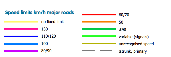
ITO Map overlay showing the value in maxspeed=* for highway=motorway, highway=trunk and highway=primary for areas where speed is shown in km/h. Yellow is used for ways with maxspeed set to 'none', dark blue for 130/120/110, light blue for 100, purple for 90/80, red for 70/60 and orange for 50. Where a maxspeed is set to another value is it shown as 'tan'. If maxspeed is not set then for the above road classes the road is shown in black.